
MUD CREEK, Calif.-On a sunbaked, dust-scoured road overlooking the Big Sur coast, four men in hard hats and fluorescent vests huddle against the stiffening wind. Worry isn't in their nature, but that doesn't mean they aren't concerned.
This Wednesday morning, with the summer nearly over, portents of fall-like the wind-bring uncertainty, and uncertainty can mean trouble when you're standing on top of the largest landslide to bury Highway 1.
"Come the middle of November, we're going to start seeing big surf coming in from Hawaii, and it's going to just clobber the toe."
John Duffy is speaking. He is an engineering geologist, 63 years old, and often cited as an expert in landslide management. He is also an avid surfer.
Duffy is concerned about erosion. Loss of the toe-the 15 acres of land that the slide pushed out to sea-would compromise what they've accomplished in the last four months.
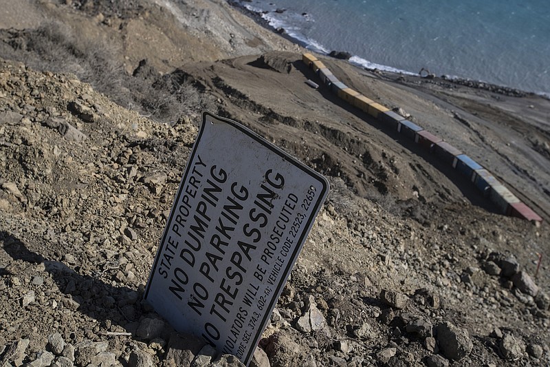
"We've already lost 100 feet of shoreline," says Lance Gorman, a major damage restoration engineer.
The men look down at the excavators and dozers maneuvering massive chunks of granite on the south flank of the toe into what looks like a breakwater just above the wrack line. A similar barrier was recently completed on the north flank.
Ever since May, when a near-vertical slope of mountain collapsed at a place called Mud Creek, teams of geologists and engineers have clawed over rocks and boulders, through brush and chaparral, to come up with a plan for reconnecting this severed artery.
The rebuilt highway, they decided, would lie on top of the slide, and the California Department of Transportation, manager of the $40 million project, hopes to see traffic flowing by the end of next summer.
Up the coast, the Pfeiffer Canyon Bridge-brought down by a landslide in February-has reopened, a Herculean demolition and construction project completed in just eight months, but Mud Creek, says Duffy, is more complicated.
Estimated to be 5 million cubic yards, the rock and mud sloughed off this mountain would by one estimate fill the Rose Bowl seven times, and while the worst seems over, Mud Creek could surprise them.
"The earth," says Duffy, "is still adjusting and trying to find a state of equilibrium."
Driven by the urgency to open the highway-visitors hoping to drive the coast, businesses and residents dependent on access-Duffy and his colleagues are practicing engineering on the fly, trying to move ahead with a long-term plan while adapting to sudden exigencies such as erosion and imminent rock falls.
Gorman pulls out a piece of slightly crumpled graph paper detailing his solution: to connect the two breakwaters, creating a solid line of rock across the width of the slide.
They pause. His plan-an additional 1,410 feet of boulders stretching nearly four football fields-means more material, more money, more time. The scale of the slide never fails to impress them.
"If you lived 1,000 years," says Augie Wilhite with John Madonna Construction, "you'd probably never see anything like this."
Caltrans has never been completely comfortable with this stretch of Highway 1, eyeing it as an adult might an errant teen. For the most part, it behaved.
Mud Creek had been a seasonal drop of water from the Silver Peak Wilderness, not even warranting mention on maps. Here cliffs had forced the highway to hug the edge, the surf a long fall just beyond the shoulder.
Last winter, Mud Creek came of age. With smaller, adjacent springs, it spilled over and under the road, which by February had dropped 4 feet. By March, construction crews had established a permanent post here with dozers and backhoes, each day a Groundhog Day as they tried to stabilize the shifting asphalt and keep a lane open.
By May, the mountain began a more serious assault.
After a routine flyover, Jonathan Warrick with the U.S. Geological Survey recalls reviewing images of the slide and seeing the road, broken into 3-foot chunks of asphalt, taking a hard right into the ocean. Warrick and other researchers study the Big Sur coast to understand the behavior of landslides and prevent disasters like La Conchita, Calif., in 2005 or Oso, Wash., in 2014.
"The Big Sur coast with its spectrum of rock types and varied topography makes a great natural landslide laboratory," says his colleague Kevin Schmidt.
One day, Warrick saw something ominous. A fissure had begun to open in a slope nearly 1,000 feet above the ocean where there was a small grove of oak trees.
"At first there were four of them, and then only three," Warrick said. "One had slipped downslope 100 feet."
On May 17, constructions crews evacuated, and three days later, during the night of May 20, the mountain collapsed, spewing 5 million cubic yards of rock and mud downslope and nearly 650 feet into the ocean.
Everyone still counts his good fortune not being here.
Within days of the mountain's failure, the reconnaissance began.
Geologists mapped not only material that slid into the sea, but also the vertical slope where that material once resided, and engineers plotted the new road.
Because there wasn't room to go around the slide, and because a tunnel would be too long, requiring nearly two miles in order to find stable ground for its entrances and exits, the best option was to go over the slide. As they sketched the plan, they secured the site.
After carving a network of roads and terraces on top of the slide, they dug a catch basin at the base of the vertical slope, where boulders-calving from above-could land without bounding into the crews below. Sixteen shipping containers, each holding three K-rails, were brought in as an additional defense.
To fight ocean erosion, they began building the twin breakwaters, technically known as revetments, on the slide's northern and southern flanks, and behind each revetment they plan to build up layers of soil and fabric to keep pressure on the hillside just below the path of the road.
For now, the road is a sinuous line on paper: two 12-foot lanes and two 4-foot shoulders with three gradual turns, tuned to 45 mph. There is talk of adding a turnout with signage explaining the nature of the slide.